Archive for the 'sport' Category

A summary of 3 months and 1 week on Ikaria

I’ve been home for almost a week now and very busy. So many things to do… not enough time to write a summary.

First things first:

Columbia Beartooth (click to open larger)

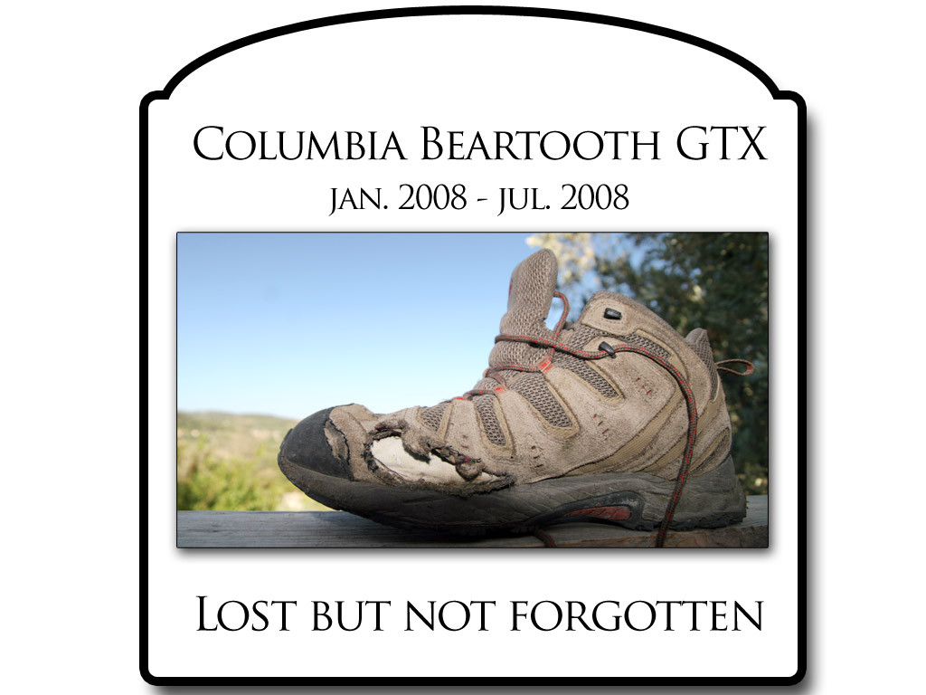
My beloved Columbia Beartooth GTX mid did not survive the 3 months of ordeal that is named Ikaria. Unfortunately they do not make the same model anymore, or the previous incarnation called Tigertooth (luckily I still have those around) as this was one of the best shoes I ever had. Extremely comfortable, amazing grip on rocks, very light, waterproof (although not anymore obviously) but sadly all those amazing properties must come with a downside. They are simply not durable enough to wear them on rough trails and off road everyday. The sole was very worn out and the first hole (big one on the photo) appeared after only 3 weeks on the island, followed closely by another one where the toe cap meets the leather. I tried to repair them as best I could by stitching up the leather but given the uncompromising location I only prolonged the ordeal for two more weeks. After that the holes just kept spreading and multiplying. Eventually I was walking around with what felt like a GoreTex sock with amazing breathability. ;)
Poor protection against spiky shrubs that are inevitable on Ikaria… But all that complaining somehow fades in comparison to Johanna’s footwear saga.
I still love my Beartooths though but unfortunately I can’t find a replacement pair anywhere. I guess I can wait while I still have the Tigertooths…

routes on Ikaria 
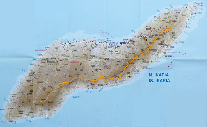
(click to open much larger map)

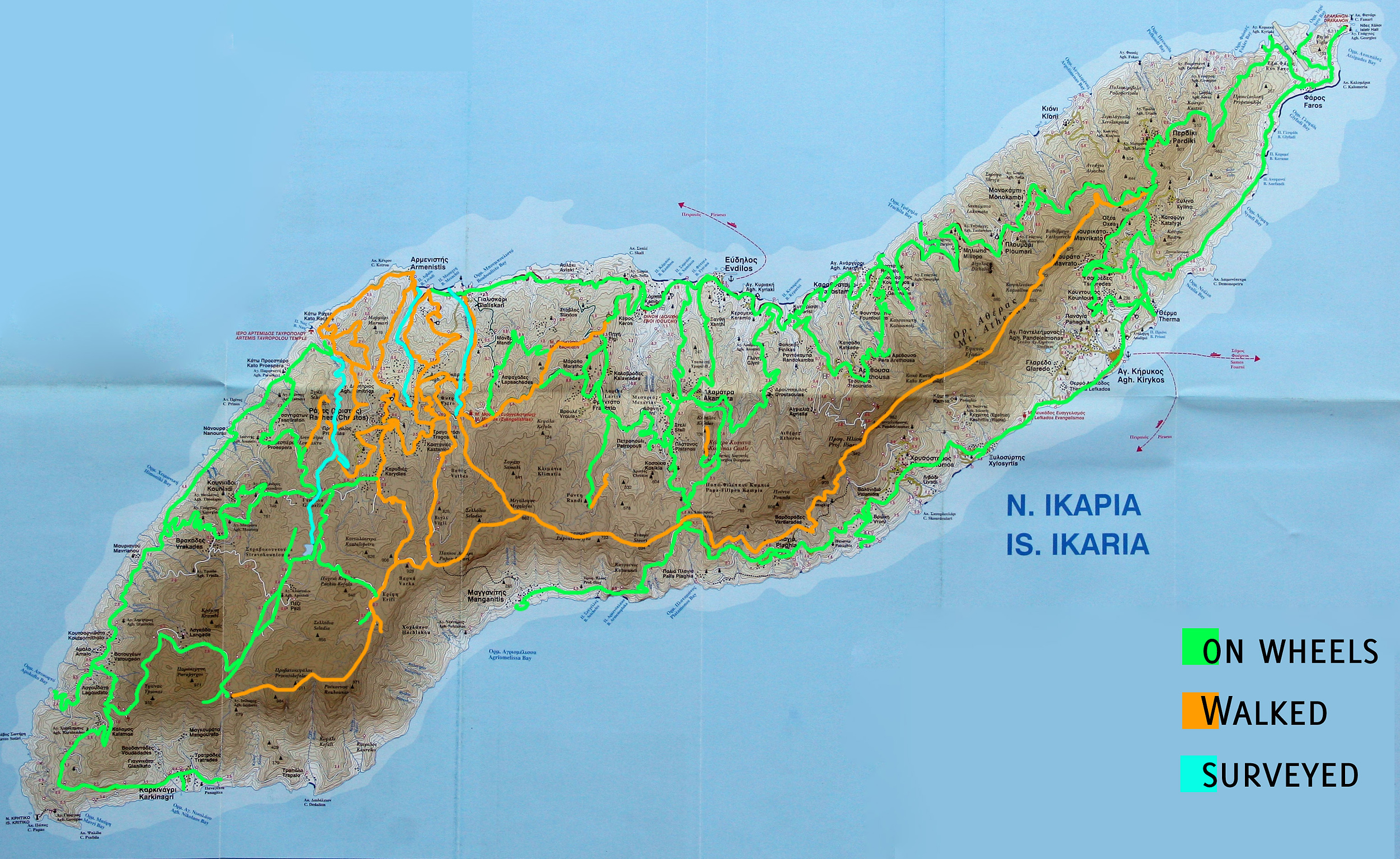
This is a sketch showing what I think are almost all the routes I walked, drove or otherwise visited while on Ikaria. Obviously it is not accurate and obviously a lot of those lines were walked and driven at some point (Suzuki Jimny baby, sorry Dimitris) ;) but I wanted to keep the map simple so only one color per road/trail. And obviously we repeated a lot of them multiple times.
The background is a photograph of Road Editions map of Ikaria.

routes on Samos (click to open larger)

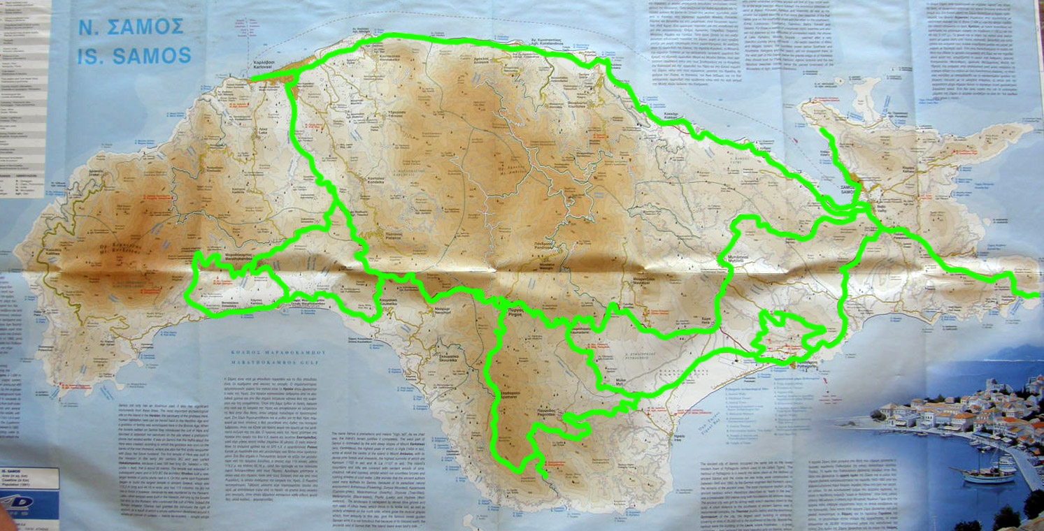
Above is a similar sketch showing the roads driven on Samos while we were coming back from Turkey. It was easter weekend and no ferries went back to Ikaria… so what can you do but rent a car… Again, background by Road Editions.

GPS measurements 
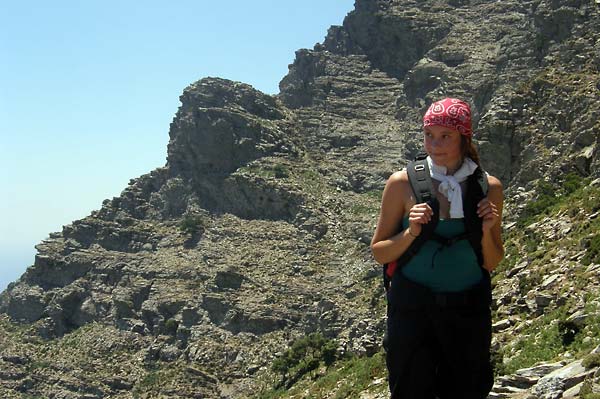
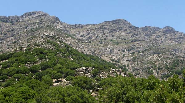
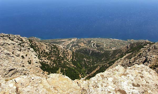
(click to open larger) copyright Archipelagos/Jernej Burkeljca/Road Editions

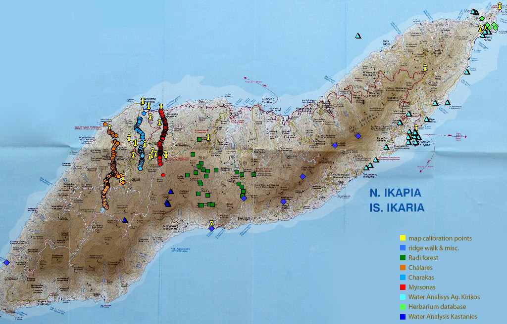
This slide from my final presentation for Archipelagos is a collection of all the GPS measurements I managed to either record on my own or dig up from old reports. Most of them are mine but I wish I recorder many more…
Recorded on Garmin e-Trex legend or Qstarz GPS receiver linked via BlueTooth to Garmin Que running under Windows Mobile on Dell Axim X51v.

Which one is better?
Well, the eTrex series are nice little units, much more useful in the field compared to my own setup (which is normally used in a car not while hiking) but the one I used had some serious connection problems at times. It had problems with terrain, with vegetation, with my pockets, clouds…
This could all be excused (since the GPS does need line of sight with the satellite) but not if the Qstarz managed to stay hooked on throughout even if I carried it at the bottom of the backpack.
I can’t comment on accuracy since I don’t have anything to compare it against. Qstarz did report about 50% lower error though (but I don’t really trust those numbers).

On my last weekend I finally managed to slip underwater with a camera to take some photos of underwater photography fieldcourse but since the camera I was using was crap that takes 3 or 4 seconds to take a photo and I didn’t have any lights (a must underwater) the photos aren’t any good. To put it plain and simple – they suck… at least I saw my first Triton’s trumpet (Charonia tritonis).
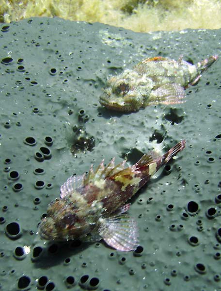
Scorpaena porcus Scorpaena (porcus?)

Charonia tritonis 
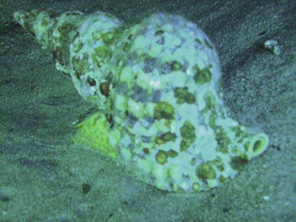
Charonia (tritonis?)

Below is the other movie I was working on towards the end… we had visits by two groups of children from schools in Perdiki and Agios Kirikos and I just basically followed them around the base and areas around it. The movie is supposed to be a short overview of what these environmental education visits are about so there’s no major editing involved. Just a nice soundtrack and voices of children in the background for a nice summer feel.


copyright Archipelagos/Jernej Burkeljca

So to end this… thank you all that made my stay on Ikaria so enjoyable and memorable! Hopefuly you know who you are. Thanks to everyone who helped out in whatever way, to everyone who picked us up when we were hitchiking (some should have the title of our regular drivers), to all that made hiking on Ikaria what it is, to everyone who cooked such nice food and everyone else that made sure I’ll come back someday. Hopefuly nobody feels left out but there’s too many of you to name and this is not an academy award speech ;)

Ridge walk

before radi
above Radi

The ridge walk from one end of Ikaria to another has been an idea some of us have had pretty much since I came here back in April. It’s been discussed, considered and planned many times but never quite to the point of execution.

Johanna & Jude on mt. Melissa

Since Jude was leaving us this week, there really was no more room for delays and excuses and with my parents on the weekend visit of the island we had a perfect logistics support system. A few days before setting off we finally managed to meet with Angelos and we also discussed the walk. Hiking Ikaria group calls this a 5/6 day Swiss walk so I was slightly concerned if this route is doable in 2 days and I just needed some more information to convince myself into what I suspected was possible.

somewhere above Plagia

Since we were feeling a bit lazy we decided beforehand to skip the hard part of climbing up from Karkinagri and focus on the ridge line itself. Ag. Isidoros was to be our starting point and the windmills on the other side of the island the end. A long way off… but definitely not 5 days away.

As it turned out the route we did could actually be completed in just one long summer day. We walked 5 hours on the first day (I had to pick up my parents coming off the ferry so we couldn’t start before the afternoon) and 8 on the second. Those 8 hours were an unfortunate result of getting slightly lost (more accurately, off the correct route) between the church of Ag. Dimitrios (above Koskina) and somewhere above Plagia. Angelos suggested that there are two ways of crossing that part. One on the ridge, one below the cliffs. We chose the latter but in the process managed to end up where we didn’t want. Very low and very far off the ridge. Eventually, after a frustrating climb up (just over 400 vertical meters) over lots of thorny and spiky vegetation in the middle of nowhere, with no real trails (and surprisingly little goat activity), we got back on the ridge and continued as planned. Estimated loss of time because of the detour was somewhere between 1 and 2 hours. The rest of the walk was much more of an easy cruise though with some short sections of jumping and climbing up and down rocks.

way up to the ridge
the way up, photo by Johanna Robinson

back on the ridge
back on the ridge, photo by Johanna Robinson

Navigation during the walk should not be much of a problem in general (ironic isn’t it?). For the most part in the western end of the island you don’t really need to follow the trail as the terrain is open and easy to walk. You may not pick the easiest or most direct route but as long as you walk in the correct general direction there should be no problems. The one part where you really need to find the trail is the section through Radi. Good luck if you don’t. You’ll be stuck in those dense trees for hours probably. We stumbled across the trail more by accident then intention. After some tough going under, over and around the trees and bushes we suddenly found ourselves on the trail and followed it out.

As we had the luxury of having someone pick us up at the end of the day we decided to travel light and not sleep in the forest. With the strong winds it would probably be impossible to catch any anyway. So we cheated (again), drove back to the comfortable beds and some proper dinner and continued from the same point the next morning.

The other tricky part can be the section the other side of the road from Radi. As mentioned previously you have two options. I can only suggest you take the one on the ridge rather than below the cliffs. If nothing else you’ll at least have a clear view of your way forward. Although, it has to be said, the cliffs are beautiful.

The eastern end of the island has a much more pronounced ridge line compared to the plateaus of the west and you’ll be able to see both sides of the island at the same time, making it a navigational no-brainer. There is one section with some trail marks (stone piles) guiding you over a slightly more exposed section. I suppose that’s the one Angelos warned us about crossing in windy conditions but even with rather strong northern winds we had on the weekend it was really straightforward to cross.

We ended the walk at the windmills (as that was the easiest and most obvious pickup point to describe) but you could easily continue towards Faros and the eastern tip of the island. It shouldn’t take more than 2 hours or so.

ridge walk
our route, click for double size

Please note this map is only an account of our route (with our unfortunate mistakes included), not the trail itself, and should not, under any circumstance, be used for critical navigation. Although the sketch was done to the best of my ability and does align quite well with the GPS waypoints I recorded it is, after all, just a sketch.

Best of the best: trail section through Radi forest, section under the cliffs above Plagia
Worst of the worst: the thorny shrub section between Zizokampos and Radi, climb back up to the ridge (as explained earlier)

Much respect to Jude for completing this walk on 1ml of water. She must have been a camel in some previous life. Huge respect for Johanna for continuing to walk around this island without any proper shoes (sandals rule!) and never complaining about thorns, spikes and rocks that must be permanently embedded in her feet by now. I don’t know how either of them did it…

Canyoning guide to Ikaria

In the past few weeks I’ve been spending quite a bit of time navigating the river canyons of Ikaria doing a river feature mapping project. The work basically involves following the river, either upstream or downstream (whichever might be easier for a given section) and marking down coordinates for pools, waterfalls and other points of interest.

I can tell you that Chalares river, for example, has over 70 swimmable pools (over 1m deep) starting from the beach in Nas and ending at Megalo fragma (dam of Chalares) and Raksounia waterfall (the second fork) with the average surface area of between 50 & 60 square meters (based on rough estimates, varies with season and amount of water) and there are about 40 waterfalls over 2m high (again, depends on amount of water).

The time it takes you to make it from one end to the other will depend greatly on your swimming habits and other variables but I’d suggest you take your time and divide the hike between at least two days. The other two major rivers in Rahes area offer a similar challenge.

If the title evoked images of canyoning of the adrenaline kind (such as the ones in the video below) I can assure you it is not the most likely situation you will find on these rivers. There’s simply not enough water to allow for such sliding or jumping over waterfalls (except in certain specific sections).

No, canyoning on Ikaria is more of a peaceful kind that takes you to places rarely seen by others since the trails mostly stay higher up on the sides of the valley.

unnamed waterfall 
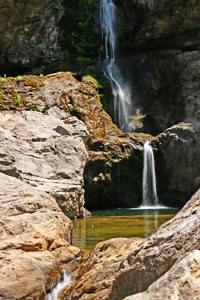
Ratsos waterfall in Chalares, photo copyright: Archipelagos/Jernej Burkeljca

upper Raksounia 
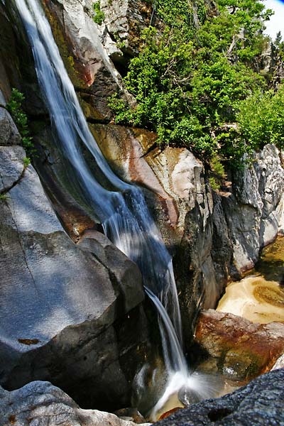
upper Raksounia waterfall, Chalares, photo copyright: Archipelagos/Jernej Burkeljca

Why such places are rarely seen becomes quickly apparent once you try to get to them. Most of them are inaccessible for the most part of the year when water levels are too high and even in the summer they can present quite a challenge.

Eva in Myrsonas 
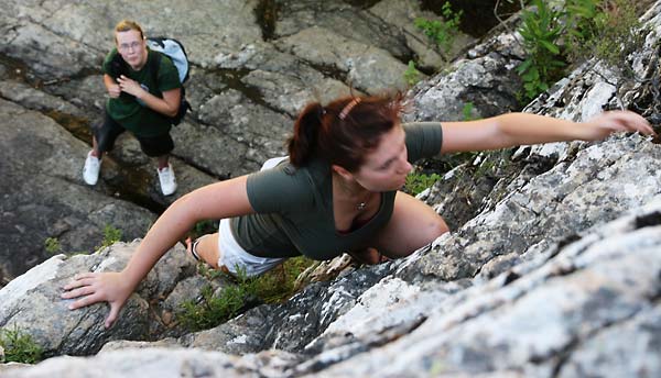
Eva & Jude climbing in Myrsonas, photo copyright: Archipelagos/Jernej Burkeljca

I would sum up the skills required into three groups. First off we have classic rock climbing. Mostly this won’t be that hard or high and can often be avoided by climbing out and around on the sides of the valley rather than over the obstacle. But not always (especially the section of Myrsonas between Vathes reservoir and the first bridge downstream) and you will have to find a way forward right over the wall, usually next to a waterfall. I would suggest bringing some safety equipment just in case you’re not too confident.

Next up is bouldering. You might argue this is the same as rock climbing but as it involves low obstacles it is not as dangerous and much more common in all of these rivers. Sometimes it might be hard to get over a particular problem but a little skill and ingenuity goes a long way.

Thirdly we have parkour. True… you may not actually need this skill per se but it sure makes life a lot easier. If you do know some of the moves and principles involved you’ll be saving a lot of time and energy getting over the obstacles.

In short that would be it. I may expand it at a future date though.

« New postsOlder posts »

Gallery